 |
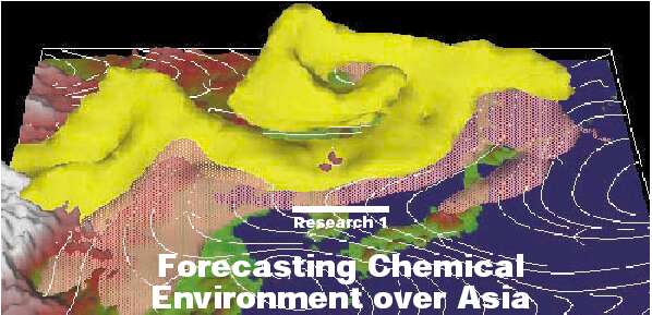
| Fig.B Simulated huge yellow sand transport (yellow isosurface) and anthropogenic origin sulfate (pink isosurface) |
| Itsushi Uno |
| Professor, Research Institute for Applied Mechanics |
|
| Fig.B Simulated huge yellow sand transport (yellow isosurface) and anthropogenic origin sulfate (pink isosurface) |
| Itsushi Uno |
| Professor, Research Institute for Applied Mechanics |
Spring dust episodes (consisting of Yellow Sand or Kosa) contribute to a number of environmental effects, including impaired visibility, mineral deposits in coastal zones, and enhanced pH levels in precipitation. The origin of yellow sand is inland desert areas (such as the Gobi and Takla Makan) on the Asian continent. The sand can be transported several thousand of kilometers to Japan by springtime strong westerly winds. This springtime yellow sand has been known as the "Spring Haze" since ancient times. The number of yellow sand episodes has, however, rapidly increased in China since 1990.
The cross-border transport of air pollutants is also a significant environmental problem in East Asia because of the very rapid increase of pollutant emissions resulting from fast economic growth. Downwind countries are now affected by acid rain and acidic aerosols. Anthropogenic aerosols and natural mineral dusts have a long residence time of more than a week, and intercontinental and/or Trans-Pacific pollutant transportation has become another important environmental issue.
In order to have better understand this cross-border air pollution and to schedule/design an operational field monitoring campaign, the ability to forecast the chemical environment over Asia has become an important research topic. Therefore, we are developing and applying an operational Chemical weather FORecasting System (CFORS) based on three dimensional regional scale chemical transport model fully on-line coupled with Regional Atmospheric Modeling System.
The purpose of traditional "Weather Forecasts" has focused only on meteorological parameters (such as precipitation, cloud cover, wind strength and temperature) that results from the movement of anti-cyclones (or cyclones). However, the target of CFORS is the chemical environment (air pollutant concentration) associated with these "weather changes." The current CFORS system includes the following chemical transport species: Anthropogenic species - SO2/SO4, CO, scoot, hydrocarbons, and NOx; Natural origin - yellow sand, sea salts, radon, and volcanic SO2. The numerical model domain is centered at 25N 115E. The horizontal grid consists of 100 by 90 grid points, with a resolution of 80 km. The vertical domain is divided into 23 layers (the top level is 20km). With this model domain configuration, we are capable of forecasting the chemical environment in Asia.
One of the unique advantages of CFORS is that the chemical transportation model is fully coupled with a regional meteorological model, and this is an important approach because the regional meteorological conditions (such as precipitation, cloud microphysics, and diurnal cycle of boundary-layer turbulence) play a significant role in the wet deposition and vertical diffusion of tracers. Chemical weather forecast calculations also need huge computer resources. The Present work adopts the PC parallel cluster system (Beowulf type 17 nodes Linux cluster) to simulate the regional scale 3-D meteorological/chemical fields. With this hardware configuration, three-day forecasting can be achieved within 4 hours, including post analysis.
CFORS got an intensive work-out during the ACE-Asia (Asia Pacific Regional Aerosol Characterization Experiment) observations, coordinated by the IGAC (International Global Atmospheric Chemistry; Fig.A) project. This intensive observation was carried out during March - April, 2001, and more than 100 researchers from several countries (Japan, Korea,China, United States and many other Asian countries) took part, using aircraft, research vessels, surface stations and numerical models. During these field studies, CFORS forecasted several huge yellow sand events. One of the biggest occurred at the beginning of April (Fig.B), and was clearly predicted to consist of a huge amount of mineral dust trapped within the cut-off vortex (low pressure) and moving to the east. This huge volume of dust (yellow isosurface) was then transported to the United States, passing over the North Pacific Ocean. Another important fact found in the experiment was that the anthropogenic pollutants such as sulfate (pink surface) are transported simultaneously with dust.
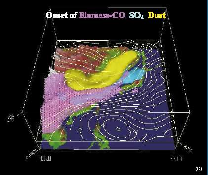
Fig. C shows the simulated typical springtime pollutant transportation pathway. It indicates that CO originating from biomass burning is transported along the south-west wind flow, with yellow sand lifted up due to the strong wind behind the cold front (which is an intermittent phenomena) set out in a north-westly direction. Furthermore, anthropogenic SO4 continuously outflows due to the synoptic high-low pressure movement. It was found that these complicated air flows (multi-scale air flows) play a significant role in our understanding of the chemical environment over Asia.
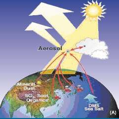
'Forecasting the Chemical Environment' is unique atmospheric environmental research and has a wide variety of applications. We are trying to improve this system to include complex atmospheric physics, chemistry, detailed land use change, and Fig.A Concept of ACE-Asia study Fig.C Typical pollutant transport pathways in spring refined anthropogenic/natural pollutant emission inventories in order to better forecast air quality in Asia.
Itsushi Uno is in the Department of Ocean-Atmosphere Dynamics, Research Institute for Applied Mechanics. He graduated from Hokkaido University and then took a position at the National Institute for Environmental Studies. He is a professor of Kyushu University since 1998 and is studying on the environmental atmospheric dynamics.