![]()


![]()
![]()
研究成果 Research Results
- TOP
- News
- Research Results
- Formation mechanism of record-breaking rainfall clarified
Formation mechanism of record-breaking rainfall clarified
Numerical simulations reproduce for the first time the convective band that produced record-breaking precipitation in northern Kyushu in July 2017 2020.10.27Research ResultsMath & DataPhysics & ChemistryEnvironment & Sustainability
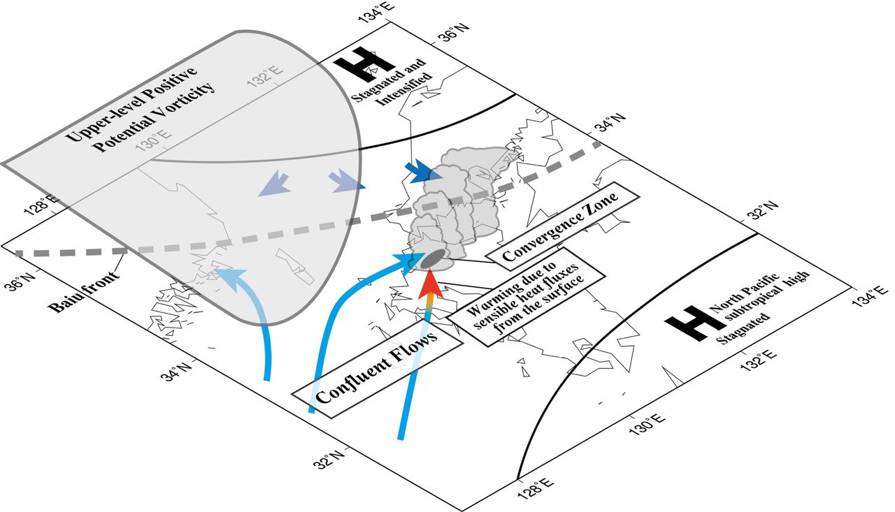
Schematic diagram of the genesis and maintenance processes of the quasi-stationary convective band that produced record-breaking precipitation in northern Kyushu in July 2017
Record heavy rainfall exceeding 600 mm over 6 hours from around noon to the night of July 5, 2017, in the Asakura region of Fukuoka Prefecture triggered a number of landslides and flash floods that resulted in a severe disaster. Researchers at Kyushu University now have new insight into what caused this record-breaking precipitation through the first high-resolution numerical simulations to reproduce this weather anomaly.
“For the first time, we have succeeded in reproducing in simulations the convective band that produced 10 consecutive hours of extreme rainfall,” says Tetsuya Kawano, assistant professor of Kyushu University’s Faculty of Sciences and first author on the study reporting the results.
“This reproduction as well as the clarification of the genesis and maintenance processes of the convective band are expected to drive the development of predictive research into similar precipitation systems in the future.”
One key feature of this heavy rainfall was the concentration of precipitation in an extremely small area—20 km long and 5 km wide—over which the 6-hour accumulated rainfall exceeded 400 mm. While this has been attributed to a band of rainfall produced by successively forming groups of cumulonimbus clouds that pass or stagnate at almost the same place for several hours, referred to as a quasi-stationary convective band, how this convective band was generated and then maintained for so long has been unclear.
Kawano and Ryuichi Kawamura, professor of the Faculty of Sciences, successfully reproduced the convective band that brought record rainfall to the Asakura region using numerical simulations with a horizontal resolution of one kilometer, which is high for weather modeling, starting more than 20 hours before generation of the band.
From their modeling, they found that blocking effects of a large-scale high pressure system located over the Sea of Japan were important for the formation and that heating of the air by the land surface was more important in the formation and intensification of this medium-scale system than topography such as surrounding mountain ranges.
“The formation environment was drastically different from previous band-shaped precipitation systems that have brought torrential rainfall to Kyushu in the past, but these results suggest that it is possible that we could accurately predict this kind of band even with the current technical level of numerical forecasting if higher-resolution simulations are conducted,” explains Kawano.
“Based on this deeper understanding, new developments in predictability are expected in the future.”
###
For more information about this research, see “Genesis and maintenance processes of a quasi-stationary convective band that produced record-breaking precipitation in northern Kyushu, Japan on 5 July 2017,” Testsuya Kawano and Ryuichi Kawamura, Journal of the Meteorological Society of Japan (2020). https://doi.org/10.2151/jmsj.2020-033
This research was supported by JSPS Grant-in-Aid for Scientific Research JP16H01846 and JP18K03744.
Research-related inquiries
Tetsuya Kawano, Assistant Professor
Faculty of Science, Kyushu University
Contact information can also be found in the full release.
- TOP
- News
- Research Results
- Formation mechanism of record-breaking rainfall clarified